| Products / Mapping Handhelds / GPSMAP76

The GPSMAP 76 adds an Americas, European or Pacific basemap and 8 megabytes (MB) of map storage space to the other outstanding features of the mariner-friendly 76-series navigators.
Use on Land or Water
Don't worry about losing this GPS device in the drink. The GPSMAP 76 floats in water, and it's IPX7 waterproof to withstand the accidental dunk or splash in the lake. Whether on water or land, the GPSMAP 76 can save up to 1000 of your favorite places in memory and takes you directly to your destination.
Store More Data
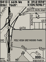
The GPSMAP 76 is preloaded with a basemap of principle cities, interstates (including exits), highways and roads as well as marine navigation aids, including lights, buoys, sound signals and day beacons. It also has 8 MB of internal memory, so you can load detailed maps from a variety of optional MapSource® products. If you're into boating, hunting or fishing, you can use the 76's built-in celestial data, which includes tide information, sunrise/sunset times and a hunting and fishing calendar.
GPSMAP 76: Rugged handheld navigation for your land and sea adventures
Physical & Performance: |
| Unit dimensions, WxHxD: |
2.7" x 6.2" x 1.2" (6.9 x 15.7 x 3.0 cm) |
| Display size, WxH: |
1.6" x 2.2" (4.1 x 5.6 cm) |
| Display resolution, WxH: |
180 x 240 pixels |
| Display type: |
4 level gray LCD |
| Weight: |
7.7 oz (218 g) with batteries |
| Battery: |
2 AA batteries (not included) |
| Battery life: |
16 hours |
| Waterproof: |
yes (IPX7) |
| Floats: |
yes |
| High-sensitivity receiver: |
no |
| Interface: |
serial |
| RoHS version available: |
yes |
Maps & Memory: |
| Basemap: |
yes |
| Preloaded street maps: |
no |
| Ability to add maps: |
yes |
| Built-in memory: |
8 MB |
| Accepts data cards: |
no |
| Waypoints/favorites/locations: |
1000 |
| Routes: |
50 |
| Track log: |
10,000 points, 10 saved tracks |
Features: |
| Automatic routing (turn by turn routing on roads): |
no |
| Electronic compass: |
no |
| Barometric altimeter: |
no |
| Geocaching-friendly: |
no |
| Outdoor GPS games: |
no |
| Sun and moon information: |
yes |
| Tide tables: |
yes |
| Area calculation: |
yes |
| Custom POIs (ability to add additional points of interest): |
no |
| Unit-to-unit transfer (shares data wirelessly with similar units): |
no |
| Picture viewer: |
no |
|
|
|
|