| Products / Mapping Handhelds / GPS 152

Get quality chartplotting with the GPS 152, a grayscale chartplotter with easy-to-use features that fits both your boat and your budget.
Find Marine Points of Interest
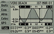
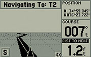
The GPS 152 comes preloaded with a marine database that includes cities as well as nautical navigation aids: lights, buoys, sound signals, day beacons and tide data. You can add even more points of interest data to the 152 with its built-in one megabyte of memory. And the 4-inch diagonal high-contrast display makes it easy to see and navigate to waypoints or other places.
Acquire Satellites Quickly
The 152 acquires satellites quickly with its 12-parallel channel receiver. It can also receive position corrections from the Wide Area Augmentation System (WAAS), which makes its already-accurate positioning data even more reliable. In fact, when you turn on WAAS, you can increase the accuracy of the 152's position reporting to within three meters
Physical & Performance: |
| Unit dimensions, WxHxD: |
5.0" x 4.9" x 2.5" (13.4 x 12.5 x 6.1 cm) |
| Display size, WxH: |
3.5" x 2.3", 4.0" diagonal (8.9 x 5.8 cm, 10.2 cm diagonal) |
| Display resolution, WxH: |
160 x 100 pixels |
| Display type: |
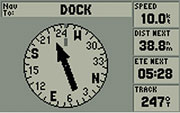
4-level grayscale LCD |
| Weight: |
less than 1 lb (454 g) |
| Battery: |
non |
| Battery life: |
non |
| Waterproof: |
yes (IPX7) |
| High-sensitivity receiver: |
no |
| Interface: |
internal or remote |
| RoHS version available: |
no |
Maps & Memory: |
| Basemap: |
no |
| Preloaded street maps: |
no |
| Ability to add maps: |
accepts points of interest data |
| Built-in memory: |
1 MB |
| Accepts data cards: |
no |
| Waypoints/favorites/locations: |
500 |
| Routes: |
20 |
| Track log: |
2,048 points |
Features: |
| Automatic routing (turn by turn routing on roads): |
no |
| Sun and moon information: |
yes |
| Tide tables: |
yes |
| Area calculation: |
no |
|
|
|
|