| Products / Mapping Handhelds / Fishfinder 140

The Fishfinder 140 combines a 4-inch grayscale display and Garmin’s exclusive fishfinder technology into an entry-level sonar that's perfect for any vessel where space is at a premium.
Pinpoint Your Next Catch
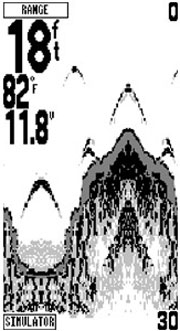
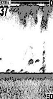
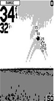
Fishfinder 140's included dual-beam transducer provides excellent shallow-water performance, and the wide viewing angle lets you see fish even off the sides of the boat. With an easy-to-ready grayscale display and backlight, the Fishfinder 140 has one of the sharpest screens for the money.
See Fish Clearly
Fishfinder 140 also offers Ultrascroll™, which refreshes the screen with lightning speed so you always see the most up-to-date information. You can manually adjust the gain or set to Auto Gain, which adjusts the level of detail you see automatically.
Other features:
- Automatic display re-scaling on range change (no more vertical lines with range changes)
- Power output: 100 watts (RMS), 800 watts (peak to peak)
- See-Thru® technology: shows weak and strong returns simultaneously
- Automatic backup of settings: unit remembers user settings when it's turned off
- Whiteline shows you how thick the bottom is
- 2X and 4X automatic and manual zoom
- Alarms for fish size, shallow water, deep water, low battery
- Battery voltage indicator
Physical & Performance: |
| Unit dimensions, WxHxD: |
6.1" x 4.9" x 2.6" (15.5 x 12.5 x 6.6 cm) |
| Display size, WxH: |
3.2" x 3.1" (8.1 x 7.9 cm) |
| Display resolution, WxH: |
128 x 240 pixels |
| Display type: |
4-level grayscale FSTN |
| Weight: |
18.7 oz (530 g) |
| Battery: |
2 AA batteries (not included) |
| Battery life: |
up to 28 hours |
| Waterproof: |
yes (IPX7) |
| Floats: |
no |
| High-sensitivity receiver: |
no |
| Interface: |
serial and USB |
| RoHS version available: |
yes |
Maps & Memory: |
| Basemap: |
no |
| Preloaded street maps: |
no |
| Ability to add maps: |
accepts points of interest data |
| Built-in memory: |
1 MB |
| Accepts data cards: |
no |
| Waypoints/favorites/locations: |
500 |
| Routes: |
50 |
| Track log: |
10,000 points, 20 saved tracks |
Features: |
| Automatic routing (turn by turn routing on roads): |
no |
| Electronic compass: |
no |
| Barometric altimeter: |
no |
| Geocaching-friendly: |
yes |
| Outdoor GPS games: |
yes |
| Sun and moon information: |
yes |
| Tide tables: |
no |
| Area calculation: |
yes |
| Custom POIs (ability to add additional points of interest): |
no |
| Unit-to-unit transfer (shares data wirelessly with similar units): |
no |
| Picture viewer: |
no |
|
|
|
|