| Products / Mapping Handhelds / GPSMAP60

Backwoods, boundary waters, blue highways — the GPSMAP 60 is your trusted guide to the great outdoors. The GPSMAP 60 and its counterpart, the GPS 60, are packed with several of the features found in the 60-series color navigators, but sport an affordable, high-resolution monochrome display for outdoor enthusiasts on a budget.
Get Rugged Navigation
The robust, waterproof GPSMAP 60 is the perfect, low-cost navigator for wherever your spirit of adventure takes you:
- Built-in basemap with automatic routing capabilities to guide you, turn-by-turn, with tone prompts to your destination
- Large, sunlight-readable, four-level grayscale display with bright LED backlight makes it easy to find your way, day or night
- 28 hours of battery life for more hours of outdoor enjoyment
- WAAS-enabled for even more precise location and navigation
- Both serial and USB connections for fast and versatile connection to your computer
Get Fun-filled Features
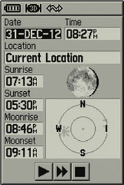
GPSMAP 60 has 24 megabytes (MB) of internal memory for storing marine, topo and city street maps from optional MapSource® mapping software. Just find the place you want to go to, and the GPSMAP 60 can route you there, on roads or off. The GPSMAP 60 also offers special geocaching features, indoor and outdoor games, an alarm clock, sunrise/sunset and moon phase tables, optimal hunting and fishing times — plus much more.
GPSMAP 60: Making it easy to navigate the great outdoors.
Physical & Performance: |
| Unit dimensions, WxHxD: |
2.4" x 6.1" x 1.3" (6.1 x 15.5 x 3.3 cm) |
| Display size, WxH: |
1.5" x 2.2" (3.8 x 5.6 cm) |
| Display resolution, WxH: |
160 x 240 pixels |
| Display type: |
4 level gray LCD |
| Weight: |
7.0 oz (198 g) with batteries |
| Battery: |
2 AA batteries (not included) |
| Battery life: |
up to 28 hours |
| Waterproof: |
yes (IPX7) |
| Floats: |
no |
| High-sensitivity receiver: |
no |
| Interface: |
serial and USB |
| RoHS version available: |
yes |
Maps & Memory: |
| Basemap: |
yes |
| Preloaded street maps: |
yes |
| Ability to add maps: |
yes |
| Built-in memory: |
24 MB |
| Accepts data cards: |
no |
| Waypoints/favorites/locations: |
500 |
| Routes: |
50 |
| Track log: |
10,000 points, 20 saved tracks |
Features: |
| Automatic routing (turn by turn routing on roads): |
yes |
| Electronic compass: |
no |
| Barometric altimeter: |
no |
| Geocaching-friendly: |
yes |
| Outdoor GPS games: |
yes |
| Sun and moon information: |
yes |
| Tide tables: |
no |
| Area calculation: |
yes |
| Custom POIs (ability to add additional points of interest): |
no |
| Unit-to-unit transfer (shares data wirelessly with similar units): |
no |
| Picture viewer: |
no |
|
|
|
|