| Products / Mapping Handhelds / Fishfinder 400C
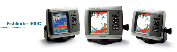
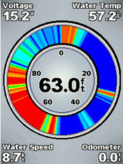
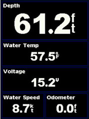
The versatile Fishfinder 400C has a super bright, high resolution 4-inch display and is great for finding fish in both freshwater and saltwater.
Use in Freshwater and Saltwater
The 400C is available with a choice of dual beam or dual frequency transducers, so it’s readily adaptable for both freshwater and saltwater fishing. The 400 watt (RMS) dual beam version offers a wide fish-finding cone and reaches depths of 900 feet. With the 500 watt (RMS) dual frequency transducer, you can reach a depth of 1,500 feet.
Connect with CANet®
Fishfinder 400C features a crisp, ultra-bright 4” QVGA color display, plus UltraScroll™ for screen updates at live-action speeds. It's also CANet-compatible, so you can share sonar information with plotters located elsewhere in your boat.
Other features:
- Automatic display re-scaling on range change (no more vertical lines with range changes)
- Power output: 100 watts (RMS), 800 watts (peak to peak)
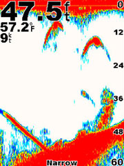
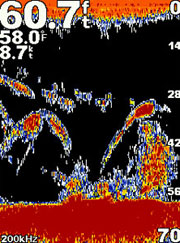
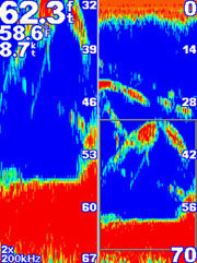
- See-Thru® technology: shows weak and strong returns simultaneously
- Automatic backup of settings: unit remembers user settings when it's turned off
- Whiteline shows you how thick the bottom is
- 2X and 4X automatic and manual zoom
- Alarms for fish size, shallow water, deep water, low battery
- Battery voltage indicator
Physical & Performance: |
| Unit dimensions, WxHxD: |
5.7" x 5.0" x 2.9" (14.5 x 12.7 x 7.4 cm) |
| Display size, WxH: |
2.6" x 3.3" (6.5 x 8.5 cm) |
| Display resolution, WxH: |
240 x 320 pixels |
| Display type: |
QVGA |
| Weight: |
17.6 (499 g) |
| Battery: |
2 AA batteries (not included) |
| Battery life: |
up to 28 hours |
| Waterproof: |
yes (IPX7) |
| Floats: |
no |
| High-sensitivity receiver: |
no |
| Interface: |
serial and USB |
| RoHS version available: |
yes |
Maps & Memory: |
| Basemap: |
no |
| Preloaded street maps: |
no |
| Ability to add maps: |
accepts points of interest data |
| Built-in memory: |
1 MB |
| Accepts data cards: |
no |
| Waypoints/favorites/locations: |
500 |
| Routes: |
50 |
| Track log: |
10,000 points, 20 saved tracks |
Features: |
| Automatic routing (turn by turn routing on roads): |
no |
| Electronic compass: |
no |
| Barometric altimeter: |
no |
| Geocaching-friendly: |
yes |
| Outdoor GPS games: |
yes |
| Sun and moon information: |
yes |
| Tide tables: |
no |
| Area calculation: |
yes |
| Custom POIs (ability to add additional points of interest): |
no |
| Unit-to-unit transfer (shares data wirelessly with similar units): |
no |
| Picture viewer: |
no |
|
|
|
|